In the Garden State, property ownership is governed by a sophisticated legal framework known as the Municipal Land Use Law (MLUL). Whether you are acquiring a brownstone in Jersey City, evaluating a commercial lot in Edison, or planning a coastal development in Toms River, the success of your investment hinges on one critical factor. Your property’s zoning classification. Understanding New Jersey’s 564 unique municipalities requires more than just a cursory glance at a map. It demands a professional understanding of land use districts, bulk requirements, and state level environmental overlays. This guide provides a comprehensive, expert level roadmap to finding your property’s zone and decoding the regulations that dictate its future utility.
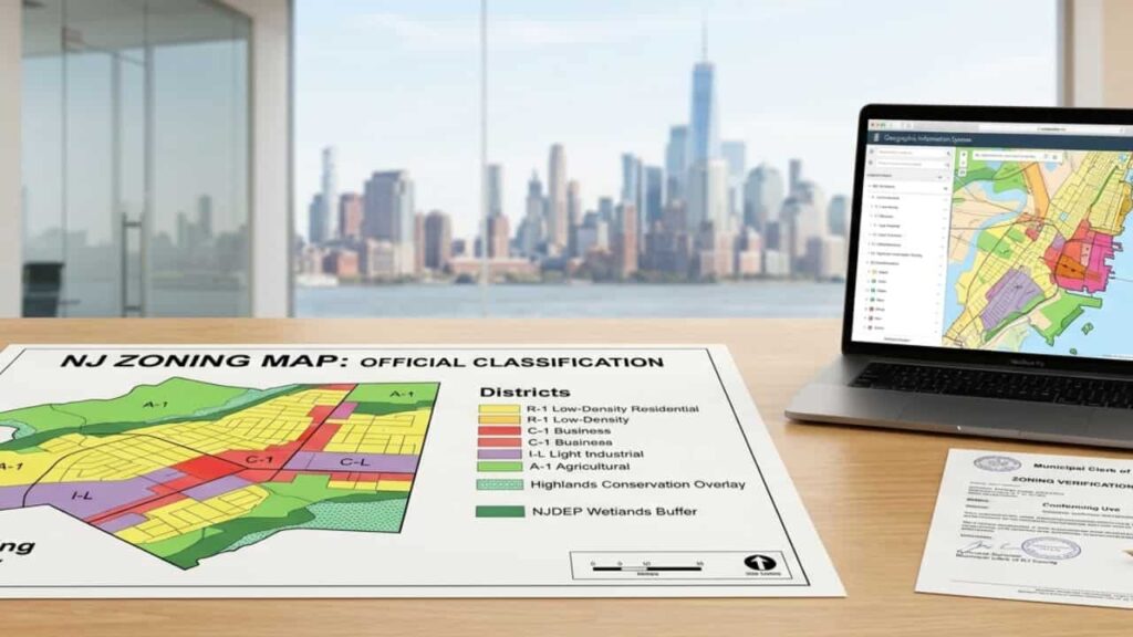
What is an NJ Zoning Map? (Understanding the Blueprint)
A zoning map is an official legal document adopted by a municipality that divides land into various “districts” or “zones”. Each zone has its own set of rules, governed by the New Jersey Municipal Land Use Law (MLUL). Unlike a tax map, which focuses on boundaries and ownership, a zoning map dictates the utility of the land. It tells you if you can build a house, open a retail store, or set up a warehouse.
Key Factors Controlled by Zoning
- Permitted Use. Defines if the lot is for residential, commercial, or industrial use.
- Bulk Requirements. Sets the building height and density limits.
- Setbacks. The mandatory distance between a structure and the property lines.
- Lot Coverage. The percentage of the lot that can be covered by “impervious surfaces” like roofs or concrete.
Step by Step, How to Find Your Property’s Zone in New Jersey
To get authentic and official information, follow these steps. Avoid third party websites that may have outdated data.
Step 1. Check the Official Municipal Website
New Jersey is a “Home Rule” state, meaning each of its 564 municipalities manages its own zoning. Search for the town’s Zoning Department or Planning Board page. Most towns provide a PDF map or an interactive GIS (Geographic Information System) tool.
Step 2. Use NJDEP GeoWeb for Environmental Data
Sometimes, state laws override local zoning. The NJDEP GeoWeb tool is a professional grade resource used to check for wetlands, flood zones, or Highlands jurisdiction that might restrict development regardless of the local zone.
Step 3. Consult the Zoning Officer
For 100% certainty, contact the local town hall. Requesting a Zoning Verification Letter is the most professional way to confirm a property’s status for legal or financial purposes.
Common NJ Zoning Codes & Practical Use Cases
Every town uses specific codes. While they vary slightly, the following table represents the standard nomenclature used across most of New Jersey.
| Zoning Code | Classification Name | Common Permitted Uses |
| R-1 / R-2 | Single Family Residential | Detached houses, parks, and home based businesses. |
| B-1 / C-1 | Neighborhood Business | Retail stores, offices, and personal services. |
| M-U / CBD | Mixed Use / Downtown | Apartments located above ground floor retail shops. |
| I-L / IND | Industrial / Light Industrial | Warehousing, distribution, and manufacturing. |
| OSR | Open Space & Recreation | Public parks and conservation land. |
Decoding the “Zoning Schedule” (Bulk Matrix)
Once you find your code (e.g., R-1), you must check the Zoning Schedule. This is often a table at the end of the town’s ordinance that lists the “Bulk Requirements”.
Professional Tip. If your property doesn’t meet the current requirements (e.g., the house is too close to the street), it may be labeled as “Legal Non Conforming.” This is common in older NJ towns.
Common Constraints to Look For
- Frontage. The width of the lot facing the street.
- Floor Area Ratio (FAR). The ratio of the total building floor area to the size of the lot.
- Height Limits. Usually measured in feet or stories.
What to Do If Your Project Doesn’t Fit the Zone?
If you want to build something that the current zoning map doesn’t allow, you must apply for a Zoning Variance through the local Zoning Board of Adjustment.
Types of NJ Variances
- “C” Variance (Bulk Variance). For deviations in setbacks or height due to the unique shape of the land.
- “D” Variance (Use Variance). To use the property for a purpose not allowed in that zone (e.g., turning a house into an office).
Fundamental Constraints Governed by Zoning.
- Permitted Use. Explicitly defines if a lot can be used for residential, commercial, industrial, or mixed use purposes.
- Bulk Requirements. Regulates the physical dimensions of structures, including height, density, and floor area ratios (FAR).
- Setbacks. The mandatory “clearance” distances from front, side, and rear property lines where construction is prohibited.
- Lot Coverage. A critical NJ metric that limits the percentage of land covered by “impervious surfaces” like rooftops, driveways, and decks.
Conclusion
Understanding the complexities of New Jersey’s zoning maps requires more than technical diligence. It demands a strategic understanding of the Municipal Land Use Law (MLUL). By leveraging official municipal GIS data and authenticating your property’s “Highest and Best Use,” you mitigate the risk of costly enforcement actions or denied permits. In the Garden State’s high stakes market, understanding these regulatory blueprints is the ultimate safeguard for your capital, ensuring that every development or acquisition is built on a foundation of legal certainty and long term investment viability.
FAQs
How do I find the official zoning ordinance for my NJ town?
To access the official zoning ordinance, visit your municipality’s website and look for the “General Ordinances” or “eCode360” portal. Most New Jersey towns use these platforms to host their updated land use laws. It is critical to cross reference the map with the “Schedule of Requirements” to understand specific bulk requirements like setbacks and building height.
What is a “Zoning Permit” and do I need one in New Jersey?
Yes, in New Jersey, a Zoning Permit is usually the first step before obtaining a construction permit. It is an official document issued by the local Zoning Officer confirming that your proposed project (like a deck, fence, or addition) complies with the town’s specific zoning map and land use regulations.
Can I build on a property located in a NJ Flood Zone?
Building in a flood zone is possible but highly regulated by both local zoning and NJDEP (New Jersey Department of Environmental Protection) standards. You will likely need a Flood Hazard Area Permit and must adhere to strict “Lowest Floor Elevation” requirements. Always check the NJDEP GeoWeb tool to see how state level environmental overlays impact your local zoning permissions.
What is the difference between a “C” Variance and a “D” Variance?
Under the NJ Municipal Land Use Law (MLUL), variances provide relief from zoning rules.
“C” Variance (Bulk Variance). Deals with physical constraints like lot area or setbacks.
“D” Variance (Use Variance). Requested when you want to use a property for a purpose not permitted in that zone (e.g., a commercial business in a residential zone). This requires proving “special reasons” to the Zoning Board of Adjustment.
How does “Lot Coverage” affect my property development in NJ?
Lot Coverage is a crucial metric in NJ zoning that limits the percentage of your lot covered by impervious surfaces (structures, driveways, or concrete). Many NJ towns have strict “Stormwater Management” rules; exceeding your allowed lot coverage can lead to permit denials or the requirement of expensive drainage systems like “dry wells”.