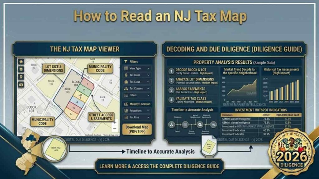
In the New Jersey real estate market, a property’s street address is merely a social convention. For serious investors, developers, and attorneys, the only “source of truth” regarding a property’s identity is the Municipal Tax Map. The New Jersey operates under a unique administrative structure where every square inch of land is categorized by Block and Lot numbers. Understanding how to interpret these technical drawings is the difference between a successful acquisition and a costly boundary dispute. This guide provides a professional grade breakdown of how to analyze NJ tax maps to extract dimensions, easements, and parcel history with surgical precision.
The Anatomy of an NJ Tax Map
A tax map is a formal graphic representation of all land parcels within a specific municipality. Unlike a survey, which is a high precision measurement of a single lot, a tax map is a “macro” tool used by the Tax Assessor and the NJDEP to track land ownership and tax liability.
Key Components of the Tax Map
| Component | Professional Definition | Utility for Investors |
| Block Number | A large geographic area, usually bounded by streets. | Identifies the general neighborhood location. |
| Lot Number | The specific parcel identifier within a Block. | The primary key for searching liens and tax history. |
| Dimensions | Numerical annotations along property lines. | Estimates total acreage and buildable footprint. |
Step by Step, How to Locate and Read a Parcel
To perform an accurate property search in 2026, you must move beyond the “Marketing Flyer” and look at the official state verified data. Follow this professional sequence.
1. Identify the Block and Lot (MOD-IV)
Before opening a map, you need the parcel identifiers. In New Jersey, this is found in the MOD-IV Tax Assessment Database.
- Search by address to find the Block (e.g., Block 102) and Lot (e.g., Lot 5).
- Note any “Qualifiers” (e.g., Q01 for farmland or C01 for condos).
2. Access the Official Map Portal
Most NJ counties, such as Monmouth, Bergen, and Ocean, provide digital access through their respective County Clerk or GIS websites.
- Tip. Use the NJ Association of County Tax Boards portal for a centralized search.
3. Interpret Map Symbols and Annotations
Tax maps use a specific shorthand that can be confusing to the uninitiated.
- Solid Lines. Denote property boundaries.
- Dashed Lines. Often indicate easements (utility, drainage, or access).
- Circled Numbers. Usually represent the “Old” lot number if the property was recently subdivided.
- Acreage (AC). If a lot is large, the acreage is often written in the center of the parcel (e.g., 5.25 Ac).
Dimensions and Scale, Calculating Real World Size
Tax maps are drawn to a specific scale (often 1″ = 50′ or 1″ = 100′). While these dimensions are generally accurate for tax purposes, they are not “Title Grade” measurements.
Reading Dimensions
- Frontage. The number written along the street line. This is critical for determining if a lot meets the minimum width required for a Zoning Permit.
- Depth. The numbers along the side boundaries.
- Inferred Math. If a dimension is missing on one side of a rectangular lot, it is typically assumed to be equal to the parallel side.
Advanced Search, Subdivisions and Consolidated Lots
undefined is constantly being reshaped. You may encounter maps that look like a “puzzle” of smaller numbers.
- Subdivisions.
When a large lot is split, you might see “Lot 5.01” and “Lot 5.02.” This indicates the original Lot 5 no longer exists in its previous form. - Consolidations.
Conversely, if an investor buys three small lots to build a commercial complex, the map will eventually show them merged into a single Lot number. - Easements.
Look for the letters “P.U.E.” (Public Utility Easement) or “D.E.” (Drainage Easement). These are areas where you cannot build, even if you own the land.
Table with Critical Abbreviations in NJ Land Records
| Abbreviation | Full Term | Investor Implication |
| ROW | Right of Way | Public access or utility path; unbuildable. |
| IMP | Improvements | Refers to structures on the land (buildings). |
| L.S. | Land Surveyor | Indicates the map was prepared from a formal survey. |
The Intersection of Tax Maps and Zoning
A common mistake is assuming the tax map defines what you can build. It does not. The tax map defines ownership boundaries, while the Zoning Map defines land use.
To be a top tier investor, you must “overlay” the tax map dimensions onto the Municipal Zoning Ordinance. For example.
- Tax Map. Says your lot is 50 feet wide.
- Zoning Ordinance. Says the minimum width for a duplex is 60 feet.
- Result. You cannot build a duplex without a Bulk Variance.
Conclusion
In the competitive 2026 New Jersey real estate market, technical proficiency in interpreting Municipal Tax Maps is a critical differentiator for top tier investors. Moving beyond street addresses to understand the Block and Lot hierarchy allows you to identify precise parcel boundaries, latent easements, and subdivision potential that the general market overlooks. By integrating official MOD-IV data with spatial mapping, you secure a definitive advantage in due diligence. In the Garden State, where developable land is finite, the ability to decode these official records is your most powerful asset for mitigating risk and maximizing asset valuation.
FAQs
Where can I find a free NJ tax map online?
Most NJ tax maps are available for free through County GIS portals (e.g., Monmouth County Open Map) or the NJDEP GeoWeb platform, which allows you to toggle the “Parcels” layer.
Is a tax map as accurate as a survey?
No. A tax map is for assessment purposes and can have a margin of error. A Property Survey performed by a licensed NJ Land Surveyor is the only legally binding measurement for construction.
What does it mean if a lot has a “Q” suffix (e.g., Lot 10, Q0052)?
The “Q” stands for Qualified. This is most common in Farmland Assessment properties where the land is taxed at a lower rate due to agricultural use.
How do I find the dimensions of a lot if they aren’t written on the map?
You can use the GIS measurement tool on the county website, or refer to the filed deed at the County Clerk’s office, which contains a “Metes and Bounds” written description.
What is the “MOD-IV” database?
The MOD-IV is New Jersey’s standardized statewide property assessment system. It contains the official Block, Lot, owner name, and assessed value for every parcel.
Can a tax map change?
Yes. Tax maps are updated annually to reflect subdivisions, lot consolidations, and changes in municipal boundaries.
Why are there dashed lines inside my property on the map?
Dashed lines usually indicate easements or encroachments. This means another party (like a utility company) has rights to use that portion of your land.
What is a “Tax Map Key”?
The key is the legend located in the corner of the map sheet. It explains the scale, the symbols used, and the date the map was last revised.
How do I find out who owns the neighboring lot using a tax map?
Identify the Block and Lot of the neighbor on the map, then plug those numbers into the NJ County Tax Board search portal to see the owner of record.
What does “Condo” mapping look like?
For condominiums, you will see one large lot number for the land, with individual “Unit” numbers (often with a ‘C’ qualifier) listed in the tax records but not always drawn individually on the map.