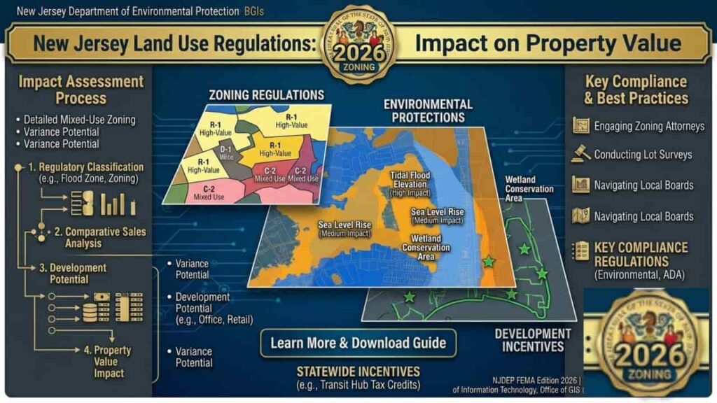
In the high stakes world of New Jersey real estate, a property’s value is dictated by more than just its zip code or square footage. It is governed by the Municipal Land Use Law (MLUL) and a dense thicket of environmental regulations enforced by the NJDEP. For sellers and investors, understanding these regulations isn’t just about legal compliance. it’s about protecting your equity. Whether you are looking at a commercial lot in Jersey City or a residential estate in Toms River, environmental designations like Freshwater Wetlands or Flood Hazard Areas act as “invisible fences” that can either skyrocket a property’s scarcity value or slash its market price by half. This expert guide analyzes how New Jersey’s regulatory landscape dictates your ROI.
The Economics of Zoning, Why Regulations Rule the Market
In New Jersey, “Value” is synonymous with “Developability.” A five acre lot isn’t inherently valuable; it is only valuable if the Zoning Map allows you to build something profitable on it. Land use regulations create a “regulatory tax” on property. When the state designates an area as a protected zone, it limits the supply of buildable land, which inherently shifts the value of every surrounding acre.
The Value Impact Matrix
| Regulation Type | Primary Impact on Value | Market Sentiment |
| Wetlands (NJDEP) | Decreases buildable acreage; high mitigation costs. | Bearish. Often leads to significant price devaluations. |
| High Density Mixed Use | Increases “Highest and Best Use” potential. | Bullish. Premium pricing for developers. |
| FEMA Flood Zones | Increases insurance premiums; restricts basement habitable space. | Neutral/Bearish. Value depends on mitigation (elevating). |
Wetlands and Riparian Buffers, The “Silent” Equity Killers
Perhaps no factor impacts New Jersey land value as drastically as the presence of Freshwater Wetlands. Under the Freshwater Wetlands Protection Act, the NJDEP regulates not just the wet areas themselves, but also a “Transition Area” (buffer) that can extend up to 150 feet from the wetland boundary.
How Wetlands Devalue Your Property?
- Loss of Footprint.
If three acres of a five acre lot are classified as wetlands, your “Effective Value” is based only on the remaining two acres. - Permitting Costs.
Obtaining a Letter of Interpretation (LOI) and specialized permits can cost thousands in engineering fees and take 6–12 months. - Mitigation Requirements.
If you are allowed to disturb a wetland, the state may require you to “buy” credits from a wetland bank, which can cost upwards of $50,000 to $100,000 per acre.
Flood Hazard Areas, 2026 Insurance and Equity Shifts
With the update to the NJ Inland Flood Protection Rule, the “Flood Zone” isn’t just a concern for shore towns like Asbury Park. Inland towns along the Passaic or Raritan Rivers are seeing property values shift as flood maps expand.
The Financial Burden of Flood Zoning
- Mandatory Flood Insurance.
Properties in a “Special Flood Hazard Area” (SFHA) require federal flood insurance for any mortgage. These premiums are a direct deduction from a buyer’s monthly purchasing power. - Substantial Improvement Rule.
If a property is in a flood zone and you want to renovate it, if the cost of the project exceeds 50% of the building’s value, the entire structure must be brought up to current flood elevation codes. - Positive Value Pivot.
Conversely, properties that have already been elevated or are located just outside the new 2026 flood boundaries are commanding a premium as “Safe Haven” assets.
Steep Slopes and Highlands Regulations
In Northern New Jersey (counties like Sussex, Passaic, and Morris), the Highlands Water Protection and Planning Act creates a dual tier value system.
- The Preservation Area.
Extremely restrictive; property values here are often suppressed unless the land qualifies for “Transfer of Development Rights” (TDR). - The Planning Area.
More flexible, but still subject to strict “Steep Slope” ordinances that prevent building on grades higher than 15–25%.
Step by Step Value Assessment for Investors
If you are evaluating a property in New Jersey, follow this professional sequence to determine if the zoning regulations are helping or hurting the price.
Step 1. Check the NJDEP GeoWeb Overlays
Before making an offer, audit the property for Wetlands, Riparian Buffers, and Known Contaminated Sites. If the map shows a green “LULC” overlay, expect a value reduction of 20–40% compared to “upland” lots.
Step 2. Review the Municipal Master Plan
Zoning isn’t permanent. Check the town’s Master Plan re examination report. If the town is planning to “Up Zone” an area from commercial to Mixed Use, the value of your property could double overnight without you laying a single brick.
Step 3. Analyze the Floor Area Ratio (FAR)
For commercial investors, the FAR determines how much “vertical” value you have. A property with a higher FAR in Newark or Jersey City is significantly more valuable than a similar lot in a suburban zone with a low FAR.
Table for Regulatory Impact on Development Potential
| Regulation | Common Restriction | Potential Value Recovery |
| CAFRA (Coastal) | Limits impervious coverage near the coast. | Designing within pre existing footprints. |
| Impervious Coverage | Limits total “paved” or “roofed” area. | Use of pervious pavers or green roofs. |
| Septic Density | Limits number of bedrooms based on soil. | Advanced treatment systems (NJDEP T-1 Permit). |
Official Agency Directory for Value Verification
| Agency | Responsibility | Contact |
| NJDEP DLRP | Wetlands & Flood Permits | (609) 777-0454 |
| Bureau of GIS | Mapping & GeoWeb Support | (609) 777-0672 |
| NJ DCA | Affordable Housing & Building Codes | (609) 292-6420 |
Conclusion
In New Jersey, land use regulations are often viewed as obstacles, but for the educated investor, they are a roadmap to value. Understanding the NJDEP and MLUL frameworks allows you to identify “undervalued” assets properties that others might avoid because they don’t understand the permit process. Whether it’s managing Wetlands mitigation or capitalizing on Transit Oriented Development incentives, your ability to interpret zoning maps is your greatest financial asset. In 2026, the most successful sellers are those who can provide “Clean” environmental reports, and the most successful investors are those who can see past a “Flood Zone” tag to find a strategic opportunity.
FAQs
How much does a “Wetlands” designation reduce NJ property value?
Depending on the severity and location, a wetlands designation can reduce land value by 30% to 70%. This is due to the loss of buildable footprint, high NJDEP permitting costs, and the potential requirement for expensive wetland mitigation credits.
Can I build on a property located in an NJDEP Riparian Buffer?
Building in a Riparian Buffer (the land next to a waterway) is strictly regulated. In New Jersey, these buffers can range from 50 to 300 feet; developing within them usually requires a Hardship Exception or a specific permit, which can be a costly and lengthy process.
What is the impact of the 2026 NJ Inland Flood Protection Rule on home prices?
The 2026 rule expanded flood hazard areas, meaning many properties previously considered “safe” now require flood insurance and must meet higher elevation standards. This increase in carrying costs typically leads to a decrease in market demand and valuation for un mitigated homes.
How does “Up Zoning” increase my property’s ROI in New Jersey?
Up Zoning occurs when a municipality changes the zoning to allow for higher density (e.g., changing a zone from single family to multi family). This increase in “Highest and Best Use” can significantly boost property value without any physical improvements to the land.
What is an NJDEP “Letter of Interpretation” (LOI) and why do I need it to sell?
An LOI is an official document from the state that confirms the presence and boundaries of wetlands on a property. Sellers with a “Clean” LOI often command a premium because they have removed the environmental uncertainty for the buyer.
Do “Steep Slope” ordinances affect property value in Northern NJ?
Yes. In counties like Morris or Passaic, building on slopes greater than 15–25% is often prohibited or requires a variance. This limits the buildable area and increases engineering costs, which downwardly pressures the initial land price.
How do NJ Highlands Regulations impact land use rights?
Properties in the Highlands Preservation Area face the state’s strictest development bans to protect water resources. Unless the property has existing “Development Rights,” its value is often restricted to its current use with very little room for expansion.
Will my property value increase if it is in an NJ Transit Village?
Generally, yes. Properties within Transit Oriented Development (TOD) zones benefit from streamlined state permitting and lower parking requirements, making them highly attractive to mixed use developers and increasing the land’s price per acre.
What is the “50% Rule” for NJ properties in flood zones?
If the cost of a renovation exceeds 50% of the building’s market value, the entire structure must be brought up to current NJDEP flood elevation codes. This “Substantial Improvement” rule can make older homes in flood zones difficult to finance or sell to flippers.
How can I check for “Invisible” land use restrictions before buying?
Investors should use NJDEP GeoWeb to check for layers such as “Known Contaminated Sites,” “CAFRA Boundaries,” and “Tidelands Claims”. Identifying these digital overlays early is the best way to avoid overpaying for restricted land.